


decauville mareconnaissance

clintest
User
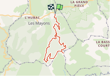

Length
18.5 km

Max alt
657 m

Uphill gradient
597 m
Km-Effort
26 km

Min alt
139 m

Downhill gradient
597 m
Boucle
Yes
Creation date :
2023-05-09 11:00:07.694
Updated on :
2023-05-09 11:00:42.998
6h01
Difficulty : Medium

FREE GPS app for hiking
 SityTrail
IGN / Geographical institutes
SityTrail Plus
The world is yours!
About
Trail On foot of 18.5 km to be discovered at Provence-Alpes-Côte d'Azur, Var, Les Mayons. This trail is proposed by clintest.
Positioning
Country:
France
Region :
Provence-Alpes-Côte d'Azur
Department/Province :
Var
Municipality :
Les Mayons
Location:
Unknown
Start:(Dec)
Start:(UTM)
287368 ; 4799794 (32T) N.
Comments